Table of Contents
i_SSS
Spatial and temporal site characteristics of agricultural crop land are important determinants regarding potential crop yield. The variation of crop yield depends mainly on the soil's attributes and the local weather conditions. Farming, which is not appropriate to the local conditions, may lead to
- in situ (affects the local ecosystem) or
- ex situ (may be caused through matter diffusion into neighboring ecosystems for example)
impairments.
To minimise environmental damages the objective of this project is the development of a Decision Support System (DSS). This system models geological and ecological processes like
- vertical matter and water transportation
- plant growth
- multiple erosion processes
with high spatial and temporal resolution and allows to asses practical measurements for a resource-efficient and environment-friendly agriculture. In addition site characteristics are determined through a combination of on-site measurement and remote sensing data.
The development of the DSS, which may be used world-wide, is divided into five work packages:
- WP 1: Implementation and integration of weather forecast models.
- WP 2: Create soil data base with high spatial resolution.
- WP 3: Evaluation and implementation of remote sensing processes.
- WP 4: Integration of models, methods and databases into decision support system.
- WP 5: Development of an efficient HPC data- and model-infrastructure.
Work Package 5
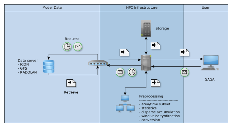
The DSS is based on the free open-source application SAGA-GIS (System for Automated Geoscientific Analyses - Geographic Information System). SAGA-GIS offers a framework for already over 650 geoscientific tools, which will be expanded by those tools, which are developed during the course of this project.
Several data sources for weather forecasts are analysed and evaluated. In the first instance the weather forecasts are retrieved by ICON runs, but other sources like GFS and RADOLAN are also used to evaluate the quality of ICON weather prediction respectively to complement it.
To reduce the amount of data, which is fed into the DSS, input data is preprocessed to reduce unnecessary content and convert it into needed formats. Nevertheless, because of the complexity and high amount of necessary computation time, SAGA-GIS respectively the DSS is deployed on HPC infrastructure. The HPC infrastructure allows a time- and storage-efficient data processing and handling, script automated workflows perform periodical data updates automatically.
SAGA-GIS respectively its tools utilise at the moment only OpenMP as parallelisation paradigm. Therefore, besides performing actions to optimise performance in general, one long-term objective is the integration of parallelisation paradigms on distributed HPC hardware into the DSS. This will be done through source-to-source translation of the OpenMP-code into equivalent MPI-3 Remote Memory Access code.
Publications
- Compiler Assisted Source Transformation of OpenMP Kernels (Jannek Squar, Tim Jammer, Michael Blesel, Michael Kuhn, Thomas Ludwig), In 2020 19th International Symposium on Parallel and Distributed Computing (ISPDC), pp. 44–51, IEEE, ISPDC 2020, Warsaw, Poland, ISBN: 978-1-7281-8947-5, 2020-07-05
Publication details – URL – DOI – Publication
- State of the Art and Future Trends in Data Reduction for High-Performance Computing (Kira Duwe, Jakob Lüttgau, Georgiana Mania, Jannek Squar, Anna Fuchs, Michael Kuhn, Eugen Betke, Thomas Ludwig), In Supercomputing Frontiers and Innovations, Series: Volume 7, Number 1, pp. 4–36, (Editors: Jack Dongarra, Vladimir Voevodin), Publishing Center of South Ural State University (454080, Lenin prospekt, 76, Chelyabinsk, Russia), 2020-04
Publication details – URL – DOI
Funding
Bayer CropScience AG
Funding period: 01.04.2016 - 31.03.2018
BASF SE
Funding period: 01.04.2018 - 31.03.2021
People from WR
- Prof. Dr. Michael Kuhn (contact person)
- Dr. Hermann Lenhart (contact person)
Principal Investigators
- Jürgen Böhner
- Thomas Ludwig
- Olaf Conrad


